
Introduction
In March, we had the opportunity to chat with Amy Sacry, former SERNW Board Member and co-founder of Geum Environmental Consulting, to learn about the first full valley reset with the goal of achieving a Stage Zero channel state in Montana. The project is part of a larger effort being undertaken by Montana Fish, Wildlife and Parks (FWP) and Montana Natural Resource Damage Program (NRDP) to reconnect degraded streams to their floodplains, enhance and expand wetland and riparian habitat, and hold water on the landscape longer into the dry season each year. This work is occurring at the Spotted Dog Wildlife Management Area (SDWMA) near Avon, Montana.
Amy talked about building a consulting firm from the ground up and reflected on the learning she’s carried forward from both her education and her fieldwork. She then walked us through the South Fork Spotted Dog Stage Zero restoration project. She conveyed a clear sense of purpose, and we’re grateful to be sharing this restoration story with you.
From Learning to Doing
Amy studied biology as an undergraduate student, which included a study abroad in Cairns, Australia where she expanded her knowledge of ecological restoration and riparian ecology. It was this experience and the deeper delve into riparian ecology that navigated her to riparian wetland postgraduate research at the University of Montana.
During her studies, Amy also gained field experience as a seasonal employee with the Bureau of Land Management (BLM). This exposed her to streambank bioengineering, riparian revegetation, and river restoration using large wood. She described the challenges of her fieldwork, the learning opportunities offered by professors and BLM leaders working on stream restoration projects, and how the BLM work ultimately contributed to her thesis research.
After her postgraduate studies, Amy worked for an environmental consulting firm, where she met her co-founders, Tom Parker and Sarah Flynn. In 2003, they started Geum Environmental Consulting and have since worked on projects throughout Montana and Idaho.
Initially focusing largely on revegetation, they eventually grew their portfolio of projects and expertise. Their staff grew along with it as they took on increasingly larger scales and varied work over the years.

Photo Credit: Geum Environmental Consulting.

Photo Credit: Geum Environmental Consulting.

Photo Credit: Geum Environmental Consulting.
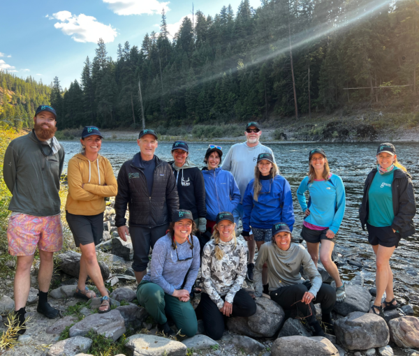
Photo Credit: Geum Environmental Consulting.
Her commitment to project restoration outcomes was evident as she spoke candidly about the realities of ecological restoration. The work demands travel, strong writing and technical skills, and resilience in challenging conditions.
Floodplain Restoration on the Spotted Dog Wildlife Management Area, Montana
The SDWMA is a 38,000 acre area purchased by the State of Montana in 2010 to protect wildlife, restore natural resources, and provide public hunting and recreation access. The purchase was funded through the NRDP.
According to FWP, portions of SDWMA existed in a degraded state due to a long legacy of livestock grazing, fluctuating populations of native grazers and browsers (i.e., elk and moose), removal of beavers, and invasion by noxious weeds and other non-native plants. Degraded streams and wetlands on the WMA have functioned well below their ecological capacity, providing diminished habitat for fish and wildlife species relative to their potential. What’s more, these streams and wetlands function below capacity for providing ecosystem services to humans, such as landscape water storage, water quality improvements, and recreational opportunities like hunting, fishing, and wildlife watching.
The restoration potential of streams and wetlands on the SDWMA were identified in 2014 when multiple tributaries in the Little Blackfoot River drainage were assessed by Geum under contract with NRDP to identify opportunities to create or enhance riparian and wetland habitat. Funding for this assessment and subsequent riparian and wetland restoration efforts is tied to the 1999 Streamside Tailings Consent Decree, which included money for the State of Montana to create or restore wetlands and riparian areas in the Upper Clark Fork River Basin.
The 2014 assessment identified extensive channel incision and loss of floodplain connectivity affecting streams on the SDWMA, resulting in the loss or reduced function of wetland and riparian areas. Further, the assessment showed that large areas of intact floodplain supporting willows and remnant channel systems were also present in many areas, increasing the potential for successful floodplain reconnection and wetland and riparian habitat creation. In 2020, working closely with FWP and NRDP, Geum began multiple phases of restoration work to reconnect several miles of streams to their floodplains and restore degraded slope wetlands on the SDWMA. The restoration efforts have contributed to the return of fauna, notably, beaver populations.
Planning and Design
Planning and design were collaborative efforts between Geum, FWP, and NRDP. NRDP’s goal was to create or enhance as much riparian and wetland area as possible with the available funds. FWP’s goal for the work was to create habitat that would allow for the expansion of beaver populations ultimately improving habitat for a wide range of species. Restoration strategies included both active and passive techniques.
LiDAR elevation data and high-resolution drone imagery guided decisions on where floodplains could be reconnected. Floodplains were reconnected through construction of main channel plugs that re-routed stream flows and allowed reconnection of large areas of historically connected floodplains. Construction of structures that mimic the effects of beaver dams were also used, such as backwatering the channel, increasing channel depth, and routing high flows onto adjacent floodplain surfaces.

Photo Credit: Geum Environmental Consulting.

Photo Credit: Geum Environmental Consulting.
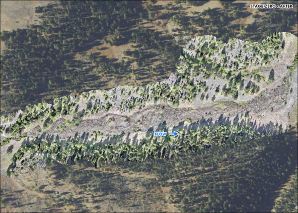
A wide valley bottom at the lower end of the South Fork of Spotted Dog Creek offered a different opportunity. The heavily incised channel did not allow for reconnection using other treatments and the floodplain did not support remnant willow communities similar to other reconnection areas. Through an interdisciplinary process, the decision was made to regrade the valley bottom to create a Stage Zero condition that would support maximum floodplain connectivity and therefore maximum riparian and wetland habitat creation.
Restoration planning and design at SDWMA also considered water supply to perennial stream channels; in these areas, floodplain reconnections were pursued. The SDWMA landscape supports a wide range of slope wetland features. These wetlands historically lacked defined channels, but a legacy of disturbance has caused many to ‘unzip,’ with headcuts forming and migrating upstream. LiDAR elevation data, aerial imagery, infrared imagery, and existing spatial data layers were used to identify where this had occurred and where restoration could restore the largest wetland areas. Designs focused on arresting headcuts and restoring natural wetland hydrology.
Implementation: Putting Plans to Work
With the goals in mind and the designs outlined, twenty-five Beaver Habitat Structures were installed, along with one main channel plug that restored surface flow to an uninhabited beaver complex. Within months, beavers reoccupied the site, building new dams and establishing a colony.
Encouraged by this success, subsequent phases in 2022 and 2024 added more structures and plugs. Similar to the first phase, beavers rapidly colonized restoration sites, building numerous new dams within days at one site. In 2024, several slope wetland restoration treatments were also completed, including regrading of a ditch that intercepted wetland flows, and construction of 85 Zeedyk rock structures to arrest headcut progression in a large slope wetland complex. Zeedyk structures are low-profile rock structures built by hand to reduce erosion and restore the hydrologic and ecological functions of wet meadows and wetlands. NRDP used the Montana-based Youth Employment Program to install these structures.

Photo Credit: Geum Environmental Consulting

Photo Credit: Geum Environmental Consulting.

Photo Credit: Geum Environmental Consulting.

Photo Credit: Geum Environmental Consulting.
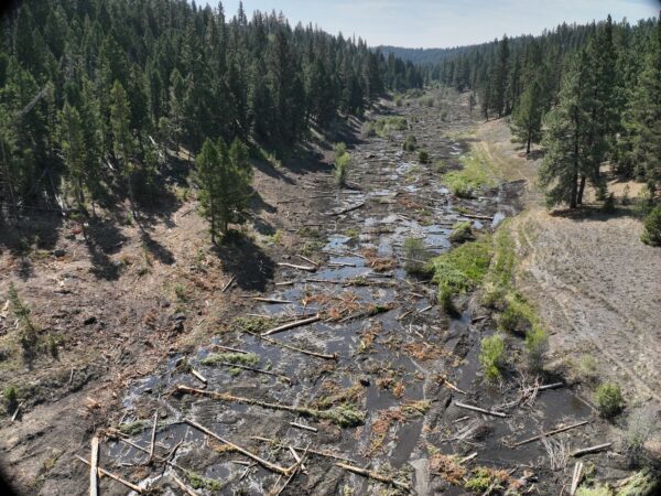
Stage Zero — A Valley Reset for lower South Fork Spotted Dog Creek
Resetting a valley bottom to a Stage Zero condition is a rare opportunity, feasible only in certain valley types. This restoration approach is a process-based design method that aims to restore the valley to the historical valley floor elevation or geomorphic grade line.1 Given that this approach to floodplain restoration is relatively new, the project team solicited technical expertise from the U.S. Forest Service Adaptive Management Services Enterprise Team.
Unlike typical Stage Zero projects where floodplain materials consist of coarse gravel and alluvium, floodplain materials at this site consist of three feet of silt loam soils. This means that rapid vegetation establishment to restore the natural biological control for floodplain erosion is key to project success. As opposed to gravel-bedded floodplains where wood is used extensively for erosion control, at this site vegetation needs to come in fast to stabilize soils and prevent soil erosion and incised channel formation.
The team is seeing that the same volume of water is entering and exiting the Stage Zero project site, but in a very different way than it did previously. In some areas, you can’t even walk across the valley bottom because the floodplain is fully engaged, with water spreading out and slowing down. That shift is creating clear habitat diversity and depth variability that did not exist before.

Photo Credit: Geum Environmental Consulting.

Photo Credit: Geum Environmental Consulting.
(July 2025).
Photo Credit: Geum Environmental Consulting.
What’s Next: Monitoring & Evaluation
To date, more than 40 acres of floodplain have been reconnected and 3 acres of headwater slope wetlands have been restored. Beaver populations are expanding throughout the restoration areas, further promoting floodplain connectivity. The Stage Zero site alone resulted in an estimated 14.2 acre-feet of additional floodplain water volume and a 2-foot rise in groundwater elevation.
Monitoring and adaptive management are a big part of the team’s work. Each year, project partners evaluate the restoration work and implement maintenance where necessary to ensure treatments continue to function. NRDP is monitoring the work to document the number of acres of wetland and riparian area the work has created or enhanced. Monitoring is also required by permitting agencies to document wetland development. High-resolution drone imagery is collected each year to document the extent of wetted area and floodplain reconnection created by restoration treatments. In addition, FWP monitors beaver populations each year, allowing project partners to understand the effect of restoration actions on beaver habitat creation and occupancy. FWP also established permanent vegetation plots to evaluate changes in vegetation compositions in response to restoration actions. Integrated Monitoring in Bird Conservation Regions (IMBCR) surveys also pass through the project area, collecting breeding bird and habitat structure data.

(July 2025).
Photo Credit: Geum Environmental Consulting.

(July 2025).
Photo Credit: Geum Environmental Consulting.
(July 2025).
Photo Credit: Geum Environmental Consulting.
- Powers et al. (2019). A process‐based approach to restoring depositional river valleys to Stage 0, an anastomosing channel network. River Research and Applications, 35(1), 3-13. https://doi.org/10.1002/rra.3378 ↩︎
Amy’s Recommended Articles
- The stream evolution triangle: Integrating geology, hydrology, and biology
- A stream evolution model integrating habitat and ecosystem benefits
- A process-based approach to restoring depositional river valleys to Stage 0, an anastomosing channel network
- Habitat conditions at beaver settlement sites: implications for beaver restoration projects
- Rediscovering, Reevaluating, and Restoring Lost River-Wetland Corridors