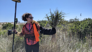
 Alexandra Evans uses remote sensing techniques (UAS, plane, and satellite) to examine historical changes in and predictors of land cover change in coastal systems, particularly on barrier islands. She is also interested in mapping invasive species cover (e.g. Phragmites), creating geospatial data to map habitat (e.g. for shorebirds), and testing/applying newer remote sensing methods (e.g. deep learning). Alexandra earned a PhD in Earth and Environmental Sciences from University of New Hampshire’s (Durham, NH) Natural Resources & Earth Systems Science PhD program in 2021, as well as a M.S. in Geology and a B.S. in Environmental Science from Rensselaer Polytechnic Institute (Troy, NY) in 2015. Alexandra’s previous work related to her dissertation explored how UAS and close-range remote sensing techniques can be used to improve river ecological assessment and restoration – particularly surrounding dam management decisions such as dam removal.
Integrating science, practice, and education in ecological restoration in the northeastern U.S.